Monitoring and mapping of marine habitat with integrated geomatics technologies
MANATEE
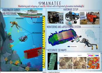
The Italian seas hold a unique biodiversity heritage in terms of species and habitats and are protected by EU conventions and directives. To effectively preserve this wealth, monitoring activities are essential to assess its health and evolution and to improve our current knowledge of natural processes and stress factors. Geomatics encompasses disciplines and techniques involving the collection, processing, analysis, visualisation and sharing of geographical data and information. Together, these approaches can provide valuable support for monitoring marine habitats in the form of: locating, navigating and mapping the site of interest using autonomous or guided approaches; generating digital twins (3D models) of the habitat with the required resolution and accuracy; extracting statistically significant metrics from the digital twins to assess temporal evolution; and presenting and sharing results with both the scientific community and the general public to promote awareness of environmental protection issues. MANATEE (Monitoring and mapping of marine hAbitats with inTegrated geomatics technologiEs) will provide these monitoring solutions through the integration of underwater photogrammetry with auxiliary positioning and navigation techniques based on acoustic, pressure and inertial sensors. The approaches developed will be implemented in three complementary submarine vehicles, differing in cost, weight and portability, number and degree of navigation, positioning sensors and 3D modelling, and designed to cover different habitats in terms of extent and depth.
UNIBO research team
Project partners
- Università di Sassari (Coordination)
- Università di Napoli Parthenope (UR local)
- Università di Bologna (UR local)